 1")
Description
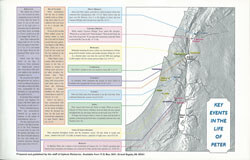
This clear, colorful ancient Roman Empire Bible map enhances New Testament stories from the Book of Acts and Paul’s Epistles. You will see where these places were 2000 years ago, and where they are today.
This Paul’s Journeys Bible wall map is perfect for Bible studies, Sunday school lessons, and homeschool curriculum for kids.
Do You Know Where These Bible Places Are Today?
-Paul was from Tarsus, a town on near the southern coast of the country of Turkey today.
-The 7 Churches mentioned in the Book of Revelation are all in modern-day Turkey, not in Greece.
-Paul and his co-workers traveled more than 9,000 miles spreading the Gospel
-Paul went to Troas, which was in the area of the ancient city of Troy.
-When Paul preached in Ephesus, it was a port city. Today the coastline has changed and the ruins of Ephesus are inland 2 miles.
This is a perfect VBS Bible map for kids because now they can see where Bible places are today. The print is large and the boundaries and colors make it easy to read. This biblical Paul’s missionary journeys wall map also goes well with adult Bible studies and children’s Sunday school classes because it helps students understand the distances people traveled.
Reviews
There are no reviews yet.